Land Dynamics
You are here
International Postgraduate Course
Land Dynamics in an Era of Change
TO BE ANNOUNCED
South Africa
Scope
Sustainable development is not easy. In many regions, including the grasslands of South Africa, physical processes such as soil erosion, alien invasive species, and inappropriate fire management threaten natural resources and human livelihoods. The interactions among such processes, especially in the context of climate change and societal developments, are hard to understand and can only be considered together, as one land system.
The dynamics of land systems (past, present, future), as well as the vulnerability to change, are determined by a set of biophysical, socio-economic, and governance drivers. The manner in which these drivers affect the components of the system accordingly determine the appearance of the landscape and its potential use. To comprehend these complex dynamics a multi/interdisciplinary approach is required where the system and all the driving components are regarded as a whole.
This course addresses the interdisciplinary and multi-scale analysis of the dynamics of land systems, covering the geological, ecological, land use, societal and governance perspectives over different scales of time and space. The main goal of the course is to investigate past and current dynamics of the region and predict possible futures in an inter- / trans-disciplinary context.
Focus and learning goals
The course aims at the study of complex land systems with a focus on the spatial variability, the multi-faceted nature, and the dynamics of these systems. The analysis requires input from multiple disciplines where the underlying processes have an inter- or trans-disciplinary character.
Specifically, after the course participants can:
- Describe the variability of complex land-use systems and landscapes from an interdisciplinary perspective;
- Conceptualize the land-use system in a broader land system, i.e., develop a conceptualized model;
- Quantitative interpretation (via models) of data;
- Derive key processes underlying the dynamics of landscapes through a combination of legacy data, field work, and stakeholder interviews;
- Have insight in the variation in techniques for landscape analyses applied in various disciplines;
- Define and analyse alternative scenarios through different techniques;
- Interpret and combine legacy data and recognize its strengths and weaknesses.
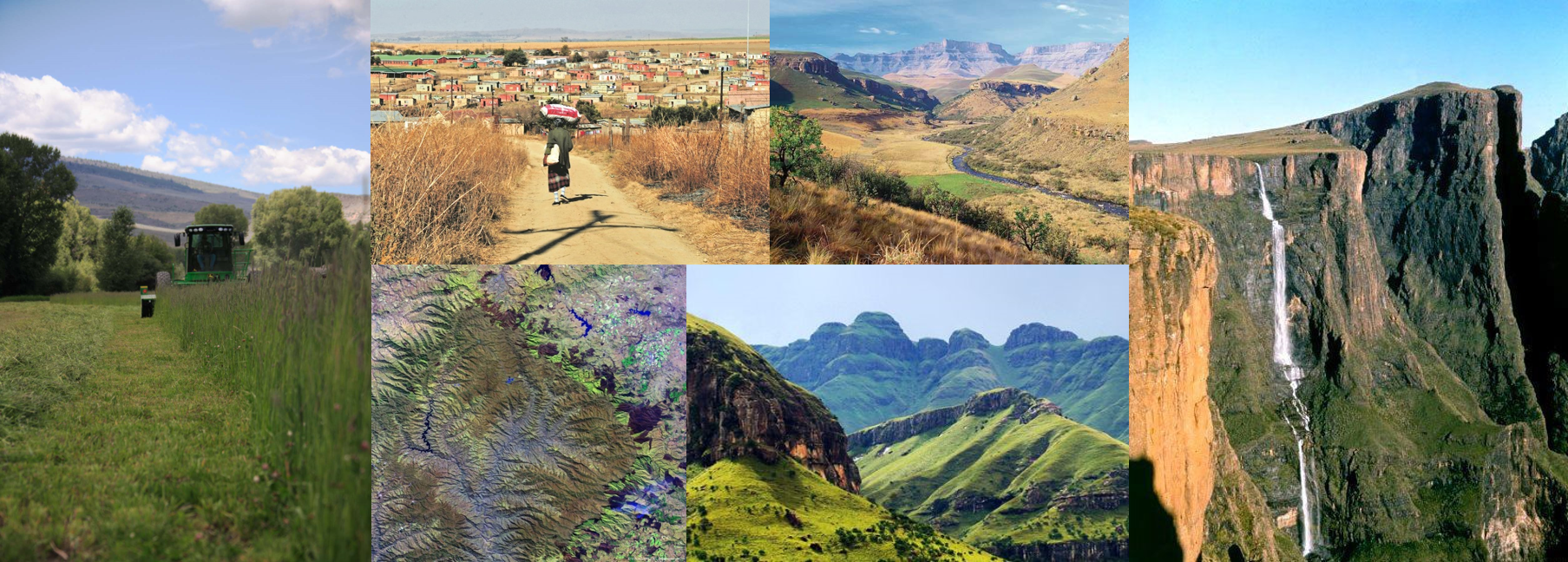
The course is held in the Northern Maloti-Drakensberg, South Africa. Land use in this area is primarily directed towards (nomadic) pastoralism, nature reserves, commercial farming, small-holder farming and (peri-)urban areas.
Course set-up
The course will involve a combination of lectures, discussions, debates, and a significant amount of group work which revolve around a set issues that the area is confronted with (see below).
Lectures
Via a series of (pitch) lectures an overview of and in-depth insight in will be given of relevant aspects of the Drakensberg region addressing geological, ecological, sociological and economic aspects at different spatio- and temporal scales. The speakers are specialists in one of the above-mentioned fields. They will be present during a significant part of the course.
Debates
Debates will be on specific topics which are highlighted in the course. The session starts with 10-minute introductions by course lecturers addressing the topic from their perspective. After a short round of questions the floor is open for a 30 minute debate on the topic addressed.
Group work
Participants will be split into 4-5 groups where each group will focus on a burning issue regarding land-use and dynamics in the Northern Maloti-Drakensberg region. During the course groups must collect, analyse and synthesise information to come with a view on the main drivers of the issue, the historical perspective, what the challenges are of the past and current dynamics and a prediction of possible futures and how the issues identified should be challenged.
For the group work the landscape has been divided in 5 different land use areas:
- The Pastoral system;
- Conservation areas;
- Smallholder agriculture / Mixed cropping and pastoralism;
- Commercial farms.
These 4 areas are confronted with an array of challenges such as:
- Soil degradation (erosion and decline soil fertility) / water supply / overgrazing;
- Invasive Species / Biodiversity (loss);
- Socio-economic instability (out-migration, depopulation, community destabilisation, poor governance).
From Virtual Walk to Actual Walk
Groups will have to describe their case area based on available literature/information. Accordingly, the landscape must be presented based on this information. Accordingly, we will visit these areas to see how reality differs from the virtual interpretation.
Collection of data will occur via:
- Literature/documentation research: A significant source of information will be available but more can be sought for via internet and local sources.
- Fieldwork/visits: The groups will visit their area and gather data through interviews and field observations. An array of factors can be included in determining the land dynamics, such as: soil fertility, erosion, water (availability, flow, distribution and quality), food security (quality and quantity), livelihood, income, labour, migration, etc.
- Modelling (primarily conceptual) will be a central element of the course that supports groups in synthesising and coming to understanding of the drivers and states of the systems’ dynamics. Participants will also be working with fussy cognitive mapping and other models (e.g. CLUE, LAPSUS, Trade-Off) for analysis as well as to create scenario’s and projections.
The group work will be spread out over the 1,5 weeks. In this period groups will regularly present their findings, where they stand, the way forward and what the possible issues might be. The rest of the attendees will accordingly reflect and give input.
The course will end with a presentation session in which each group present their final results of the past and current dynamics of the region and their prediction of possible futures.
General information
| Target Group | The course welcomes participation by academics (especially early career), managers, practitioners, professionals and governance agencies |
| Group Size | Min. 15 / Max. 25 participants |
| Course duration | 10 days |
| Language of instruction | English |
| Frequency of recurrence | Once every three years |
| Number of credits | 3 ECTS |
| Location | South Africa |
| Accommodation | Accommodation and full board catering is included in the fee of the course |
More information
Dr. Claudius van de Vijver (PE&RC)
Phone: +31 (0) 317 485116
Email: claudius.vandevijver@wur.nl
Registration
At this moment, this course is not scheduled yet. However, if you register your interest in this activity below, we will inform you as soon as the course is scheduled and registration of participation is opened.